Biking

"In the field" railroad history adventures...
Showing posts with label Schenectady Railway. Show all posts

Saturday, August 22, 2020

Glenville/Alplaus Visit

A short visit to upstate NY to visit my family is never complete without checking out railroad remnants :-)

Old Stone Railroad Bridge

This lovely stone railroad bridge can be found off Glenridge Road in East Glenville, NY.

Historical Details
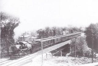
In 1881, the Boston, Hoosac Tunnel and Western Railway opened an extension west from Mechanicville to Rotterdam Junction. This was later to be incorporated into the Fitchburg Railroad which by 1919 became part of the Boston & Maine Railroad. More info >
1930 USGS Topo Map


Trolley Bridge Ruins - Alplaus, NY

I have been here numerous times... This view of the Mohawk River old trolley bridge piers is looking south. It was part of the Schenectady Railway. Historical Details >
Note kayakers
Note Birds

Wednesday, August 28, 2019

Schenectady's Past - Railroad Tributes

On August 28th, 2019, while visiting my mother, I decided to do a bit of local railroad history sleuthing rather than mountain bike. It was productive!

Schenectady

Now recently renovated as a restaurant, this building was originally a single-story waiting room for the Schenectady Railway Company - a local trolley company.

Next - although I am no fan of casinos, the Rivers Casino and Resort rose from the ashes of the former ALCO plant and I was curious if there was any mention of the history of the location.
this spot is called the Amphitheater
there are picnic tables and a green lawn (no trees tho'...)
the walk along the rivers edge was pleasant
 Sure enough... I was rewarded with a series of nicely done signage scattered around the park area!

For lunch I headed up to Ballston Spa and had a tasty burger and brew outside, at the old Chocolate Factory. On my trek back in December 2015,  I documented the local electric railway and the interesting history of this mill complex.

Although it was cloudy and gray all morning, the sun came out during lunch and I felt a wee bit guilty for not biking but nevertheless, it was an interesting and productive trek!

Sunday, December 25, 2016

Albany, NY (Historical Photos)

Well this is not really an outside adventure but it is railroad related so it best posted here.

Albany, NY

Christmas Day was spent with the family in upstate NY. We had the pleasure of dining together at Jack’s Oyster House in Albany, NY. The dining room was filled with historical photos and the old (former) D&H Headquarters in all its glory was just across the street…
Former D&H Headquarters
Schenectady Railway - Interurban
Albany Union Station

Grand Central, NYC

Later in the week, I was back home and on my evening commute through Grand Central Terminal, I decided to snap these two photos.

Vanderbilt Room 
Passageway between the Vanderbilt Room and Main Hall
Be Sure to check out other photos on the GCT page if you haven’t already:

Friday, January 1, 2016

Trolley History Tour - Ballston Spa


Ballston Spa has an interesting history of trains and street cars. At one time, it was serviced by three trolley lines and the railroad. Now of course the large curved embankment long since abandoned by the Delaware & Hudson (D&H) dominates the landscape but there are vestiges of the trolley lines around town as well if you know where to look.

On Dev 26th, before we ventured up the Kaydeross Valley in search of the old mills, Gino DiCarlo took me on a quick loop thru town. Knowing my interest in the trolley era, he wanted to point out a few “not so obvious landmarks” of once omnipresent street car lines.


Map Overview

The map below illustrates the various railroad and trolley lines including the now filled in river and "the island."
Base Map from http://www.openrailwaymap.org

Walking Tour

A walk up the short hill on Prospect Street gave us a glance at how the Kaydeross Railroad (KVRR) came in thru the town. Bath Street was the old electric railroad’s right of way. 
At the old Union Mill - looking south
This is Bath Street - built on the ROW of the Kaydeross Trolley 

We strolled on by the old Tannery...
This was once a thriving industry
...and Gino pointed out where the Schenectady Railway (SRW) snuck across what is now just an insignificant driveway to descend onto Washington Street.
Note ascending pavement - this was the route of the SRW
The old Hudson Valley Railway (HVRW) offices still stand proudly on Front Street but apparently the SRW wan’t allowed to connect with its competitor at this location. 

The two lines came close at the corner of Milton and Washington but never connected! Only when the D&H bought and merged them was a direct connection finally made!
Today
Yesteryear (from the Gino DiCarlo Collection)

Curious cement abutments right over Gordon Creek by the old hot dog place indicates where the SRW crossed and the abutments parallel to the Mechanic Street Bridge over the Kaydeross Creek are remnants of it’s continued route northward.
Looking east from Milton Avenue over the Gordon Creek crossing
Why is this strange short cement wall here? It was where the SRW crossed!
Mechanic Street Bridge
The abutment was where the SRW crossed
A dam and cement remnants at the Mechanic Street bridge are vague reminders of the early mills here

The Now Missing Island

What’s equally fascinating is that a sizable chunk of this area was actually an island replete with a foundry and a mill - appropriately named “Island Mill.” 
This view is looking east from the Rt 50 bridge over the Kaydeross -
 the area to the right was once an island!
Mills highlighted in green

What Happened to Galway Street?

Galway Street was once a rail yard.
Note Rail Yard and Turntable
See the view now -  Google Street View > 
(Galway Street at Science St intersection - looking east)

Take a Google Street View Tour

Bath Street 
At the Mills - North
https://www.google.com/maps/@43.008087,-73.8510289,3a,75y,23.9h,89.07t/data=!3m7!1e1!3m5!1sD_TIOw2XcJ9YQgexs5o_Aw!2e0!6s%2F%2Fgeo2.ggpht.com%2Fcbk%3Fpanoid%3DD_TIOw2XcJ9YQgexs5o_Aw%26output%3Dthumbnail%26cb_client%3Dmaps_sv.tactile.gps%26thumb%3D2%26w%3D203%26h%3D100%26yaw%3D95.748642%26pitch%3D0!7i13312!8i6656

At the Mills - South
https://www.google.com/maps/@43.008087,-73.8510289,3a,75y,207.23h,82.17t/data=!3m7!1e1!3m5!1sD_TIOw2XcJ9YQgexs5o_Aw!2e0!6s%2F%2Fgeo2.ggpht.com%2Fcbk%3Fpanoid%3DD_TIOw2XcJ9YQgexs5o_Aw%26output%3Dthumbnail%26cb_client%3Dmaps_sv.tactile.gps%26thumb%3D2%26w%3D203%26h%3D100%26yaw%3D95.748642%26pitch%3D0!7i13312!8i6656

The Tannery Alleyway
https://www.google.com/maps/@43.00397,-73.851308,3a,75y,218.26h,88.77t/data=!3m6!1e1!3m4!1sRo17tcW3Ai7yuZZrsB3jag!2e0!7i13312!8i6656

The Driveway Descent
https://www.google.com/maps/@43.0029997,-73.8512712,3a,75y,253.83h,71.54t/data=!3m6!1e1!3m4!1shJDD4-_oX-WMQjO5IvgoaA!2e0!7i13312!8i6656

Main Street - The Two shall Not Meet!
https://www.google.com/maps/@43.0033843,-73.8489061,3a,37.5y,12.28h,86.08t/data=!3m6!1e1!3m4!1s2P15OcFTPP6raQWkCZiTbA!2e0!7i13312!8i6656

HVRW Stop on Front Street
https://www.google.com/maps/@43.0024133,-73.85098,3a,90y,326.25h,90.29t/data=!3m6!1e1!3m4!1szYdvyHRZjjGYZtzk5N__ew!2e0!7i13312!8i6656

Milton Ave crossing Gordon Creek (SRW abutment remnants are here)
https://www.google.com/maps/@43.0048692,-73.8490806,3a,75y,123.46h,75.45t/data=!3m6!1e1!3m4!1s40WIuXqOMuH5cAMXhosy_Q!2e0!7i13312!8i6656

Mechanic Street Bridge Abutment


Saratoga County Picture Gallery

Direct Links to Timothy Starr's Historical Photos
Delaware & Hudson passing over the Kayaderosseras Creek
Source: http://ballstonhistory.angelfire.com/images/pic03.jpg
Delaware & Hudson through Ballston Spa
Note Turntable -- This was the approach to the Galway Street Rail Yard
Source: http://ballstonhistory.angelfire.com/images/pic10.jpg
Sans Souci Hotel, built in 1803 and torn down in 1887
Source: http://ballstonhistory.angelfire.com/images/souci.jpg

Further Recommended Reading


The Paper Bag King - A Biography of George West
http://ballstonhistory.angelfire.com/west.htm

Lost Industries of Saratoga County
http://ballstonhistory.angelfire.com/industrial.htm

Ballston Spa, New York (Wikipedia)
https://en.wikipedia.org/wiki/Ballston_Spa,_New_York)

Sunday, April 26, 2015

Trolley Bridge Ruins - Aqueduct , NY

Although I had visited this spot last winter (see The Mohawk River Trolley Bridge Ruins), this time I invited along both local railroad history expert Gino Di Carlo, as well as good friend from High School Gary Cunningham, who has accompanied me on quite a few other treks.

Gino is an expert on local railroad "archeology". He grew up in Aqueduct and explored everything train-related nearby as a kid. He was an encyclopedia of knowledge and shared quite a few interesting historical tidbits. He was great company!

We met at the Boat House parking lot and---much to my surprise--found a wide groomed path along the river at the end of the driveway.

We trekked in and saw large piles of stones--rubble from the canal lining ages ago.
Our Trek to the Trolley Bridge
Stone Canal Rubble 
Lots of Rubble!
Once at the piers, Gary suggested taking a photo of Gino and I to show just how massive these piers are. We looked like pipsqueaks!

A short walk in the muck provided this view
We hiked up the hill where a photo of the abutment was taken.
We then walked up the hill, following the gas line clearing, to the spot where the trolley once crossed the railroad, (see Mystery Ruins). For a short while,  Gino seemed lost  in contemplation of how it was yesteryear...
On the northwest side of the abandoned crossing, Gary encouraged a second photo op:

We next explored the long forgotten railroad spur nearby - it has a fascinating history >