Biking

"In the field" railroad history adventures...
Showing posts with label Ballston Spa History. Show all posts

Wednesday, August 28, 2019

Schenectady's Past - Railroad Tributes

On August 28th, 2019, while visiting my mother, I decided to do a bit of local railroad history sleuthing rather than mountain bike. It was productive!

Schenectady

Now recently renovated as a restaurant, this building was originally a single-story waiting room for the Schenectady Railway Company - a local trolley company.

Next - although I am no fan of casinos, the Rivers Casino and Resort rose from the ashes of the former ALCO plant and I was curious if there was any mention of the history of the location.
this spot is called the Amphitheater
there are picnic tables and a green lawn (no trees tho'...)
the walk along the rivers edge was pleasant
 Sure enough... I was rewarded with a series of nicely done signage scattered around the park area!

For lunch I headed up to Ballston Spa and had a tasty burger and brew outside, at the old Chocolate Factory. On my trek back in December 2015,  I documented the local electric railway and the interesting history of this mill complex.

Although it was cloudy and gray all morning, the sun came out during lunch and I felt a wee bit guilty for not biking but nevertheless, it was an interesting and productive trek!

Monday, February 15, 2016

Retracing the Kaydeross Railroad (Part Four)

I was back upstate for Presidents Day and convinced my friend Gary to join me for the continued trek up the Kaydeross River, exploring and documenting the old mills that were part of the Kaydeross Railroad. Sadly Gino could not join us for this trek.

Although I don't like to "repeat myself" and revisit the same spots twice - we did return to a few spots Gino and I had already visited back in December but the snow gave each spot a refreshingly different ambiance.

Pioneer Mill

First stop was the eerie (to me) Pioneer Mill. I noticed a foundation on the south side of the road I missed last time. In addition, a walk back over the creek gave a couple of new perspectives on the remaining ruins previously wandered thru and photographed.

Heisler Road Bridge

We next revisited the Heisler Road Bridge and this time wandered a bit north on the ROW. It quickly became overgrow and harder to discern where the track went amid the overgrowth and plethora of fallen trees.

Private Trolley Stop 

Our next location was a much more productive stop at George West's private trolley stop in Rock City Falls. It was a fairly easy trudge through the thick undergrowth and we were quickly rewarded with close up views of the stop and the ROW embankment that ran right next to the stone "hut."As the last photo indicates, the slate roof was already starting to deteriorate. It certainly is a shame that this has been neglected and not on "the list" of historic structures needing an historic sign and preservation...

 Theere was an old foundation nearby which probably was another house back then...

The Empire Mill

Our next stop was not visited on my last trip with Gino: The Empire Mill. There are numerous photos of this site on the web - many on a sunny beautiful day  (see Google Image Search - Empire Mill Rock City Falls NY) but my main interest was to get behind the mill and check out the old coal trestle.


 The Coal Trestle is visible from across the river...
Remnants of the Coal Trestle


 Eagle Mill
A return vist to Eagle Mill did provide a clearer view in the snow. Further across the creek were more ruins and it was tempting to try and cross the river on the ice but it really wasn't solid enough. Normally at this time of year,  crossing on the ice would have been possible but this winter has been abnormally warmer on the average so it would have been foolish to attempt it (sigh).

Axe Mill (Ballston Pulp & Paper)

On our revisit to the Axe Mill, we noticed a lawn chair and teepee (not in the photo) near the ruins across the river. Apparently some hearty souls were braving the cold and winter camping!


Sulphite Mill

Lastly, our trip to the Sulphite Mill was rewarding because (as mentioned) the ambiance was completely different with everything being blanketed by snow.

Its kind of hard to visualize in this puny picture but as we hiked back up the hill, the Planing Mill, looming high up on the hillside above us, felt like a medieval watchtower, ominously perched to guard against invading forces! :-)

We finished off the trek with Burgers and Beer at the Factory. 

The Factory, being another former mil superbly "refurbished" as a restaurant was the perfect spot to reconnect once again with the modern world.:-) 

Friday, January 1, 2016

Trolley History Tour - Ballston Spa


Ballston Spa has an interesting history of trains and street cars. At one time, it was serviced by three trolley lines and the railroad. Now of course the large curved embankment long since abandoned by the Delaware & Hudson (D&H) dominates the landscape but there are vestiges of the trolley lines around town as well if you know where to look.

On Dev 26th, before we ventured up the Kaydeross Valley in search of the old mills, Gino DiCarlo took me on a quick loop thru town. Knowing my interest in the trolley era, he wanted to point out a few “not so obvious landmarks” of once omnipresent street car lines.


Map Overview

The map below illustrates the various railroad and trolley lines including the now filled in river and "the island."
Base Map from http://www.openrailwaymap.org

Walking Tour

A walk up the short hill on Prospect Street gave us a glance at how the Kaydeross Railroad (KVRR) came in thru the town. Bath Street was the old electric railroad’s right of way. 
At the old Union Mill - looking south
This is Bath Street - built on the ROW of the Kaydeross Trolley 

We strolled on by the old Tannery...
This was once a thriving industry
...and Gino pointed out where the Schenectady Railway (SRW) snuck across what is now just an insignificant driveway to descend onto Washington Street.
Note ascending pavement - this was the route of the SRW
The old Hudson Valley Railway (HVRW) offices still stand proudly on Front Street but apparently the SRW wan’t allowed to connect with its competitor at this location. 

The two lines came close at the corner of Milton and Washington but never connected! Only when the D&H bought and merged them was a direct connection finally made!
Today
Yesteryear (from the Gino DiCarlo Collection)

Curious cement abutments right over Gordon Creek by the old hot dog place indicates where the SRW crossed and the abutments parallel to the Mechanic Street Bridge over the Kaydeross Creek are remnants of it’s continued route northward.
Looking east from Milton Avenue over the Gordon Creek crossing
Why is this strange short cement wall here? It was where the SRW crossed!
Mechanic Street Bridge
The abutment was where the SRW crossed
A dam and cement remnants at the Mechanic Street bridge are vague reminders of the early mills here

The Now Missing Island

What’s equally fascinating is that a sizable chunk of this area was actually an island replete with a foundry and a mill - appropriately named “Island Mill.” 
This view is looking east from the Rt 50 bridge over the Kaydeross -
 the area to the right was once an island!
Mills highlighted in green

What Happened to Galway Street?

Galway Street was once a rail yard.
Note Rail Yard and Turntable
See the view now -  Google Street View > 
(Galway Street at Science St intersection - looking east)

Take a Google Street View Tour

Bath Street 
At the Mills - North
https://www.google.com/maps/@43.008087,-73.8510289,3a,75y,23.9h,89.07t/data=!3m7!1e1!3m5!1sD_TIOw2XcJ9YQgexs5o_Aw!2e0!6s%2F%2Fgeo2.ggpht.com%2Fcbk%3Fpanoid%3DD_TIOw2XcJ9YQgexs5o_Aw%26output%3Dthumbnail%26cb_client%3Dmaps_sv.tactile.gps%26thumb%3D2%26w%3D203%26h%3D100%26yaw%3D95.748642%26pitch%3D0!7i13312!8i6656

At the Mills - South
https://www.google.com/maps/@43.008087,-73.8510289,3a,75y,207.23h,82.17t/data=!3m7!1e1!3m5!1sD_TIOw2XcJ9YQgexs5o_Aw!2e0!6s%2F%2Fgeo2.ggpht.com%2Fcbk%3Fpanoid%3DD_TIOw2XcJ9YQgexs5o_Aw%26output%3Dthumbnail%26cb_client%3Dmaps_sv.tactile.gps%26thumb%3D2%26w%3D203%26h%3D100%26yaw%3D95.748642%26pitch%3D0!7i13312!8i6656

The Tannery Alleyway
https://www.google.com/maps/@43.00397,-73.851308,3a,75y,218.26h,88.77t/data=!3m6!1e1!3m4!1sRo17tcW3Ai7yuZZrsB3jag!2e0!7i13312!8i6656

The Driveway Descent
https://www.google.com/maps/@43.0029997,-73.8512712,3a,75y,253.83h,71.54t/data=!3m6!1e1!3m4!1shJDD4-_oX-WMQjO5IvgoaA!2e0!7i13312!8i6656

Main Street - The Two shall Not Meet!
https://www.google.com/maps/@43.0033843,-73.8489061,3a,37.5y,12.28h,86.08t/data=!3m6!1e1!3m4!1s2P15OcFTPP6raQWkCZiTbA!2e0!7i13312!8i6656

HVRW Stop on Front Street
https://www.google.com/maps/@43.0024133,-73.85098,3a,90y,326.25h,90.29t/data=!3m6!1e1!3m4!1szYdvyHRZjjGYZtzk5N__ew!2e0!7i13312!8i6656

Milton Ave crossing Gordon Creek (SRW abutment remnants are here)
https://www.google.com/maps/@43.0048692,-73.8490806,3a,75y,123.46h,75.45t/data=!3m6!1e1!3m4!1s40WIuXqOMuH5cAMXhosy_Q!2e0!7i13312!8i6656

Mechanic Street Bridge Abutment


Saratoga County Picture Gallery

Direct Links to Timothy Starr's Historical Photos
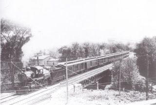
Delaware & Hudson passing over the Kayaderosseras Creek
Source: http://ballstonhistory.angelfire.com/images/pic03.jpg
Delaware & Hudson through Ballston Spa
Note Turntable -- This was the approach to the Galway Street Rail Yard
Source: http://ballstonhistory.angelfire.com/images/pic10.jpg
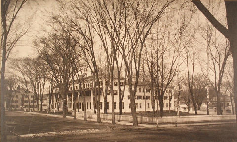
Sans Souci Hotel, built in 1803 and torn down in 1887
Source: http://ballstonhistory.angelfire.com/images/souci.jpg

Further Recommended Reading


The Paper Bag King - A Biography of George West
http://ballstonhistory.angelfire.com/west.htm

Lost Industries of Saratoga County
http://ballstonhistory.angelfire.com/industrial.htm

Ballston Spa, New York (Wikipedia)
https://en.wikipedia.org/wiki/Ballston_Spa,_New_York)