After my earlier event-filled ride at Norwalk River Valley trail, I was up for something a little calmer. Unfortunately this hike was a little too calm! - BORING? yep but still interesting being a former rail line….
The weather turned cold and gray and certainly didn’t help my perception of the trail at all. The best thing going for it is there are a lot of locals who use the trail to jog so it’s put to good use.
At the start in Ridgefield
This is it!
(about 85% of the trail is like this)
There are a few road crossings to liven things up a bit :-)
A rock cut
The highlight of the hike was when I pulled out my camera to record how boring it was and as I turned around to film - a bunch of deer scampered across the trail further uphill - that was kinda cool!
End of the Line
CloseUp
Finally back up top where I entered
The trail(ROW) just go a bit further up hill but at this trailhead there is no parking
Why didn't I bike it?
Good question! Bikes are not allowed although I did see lots of tire tracks and a teenager riding with her mother. I guess the powers that be thought that being all downhill, bikers might get careless with their speed and clip a few joggers.
Here a bit about the railroad history:
In the 1860s, the Ridgefield and New York Railroad (R&N) was proposed to offer a more direct connection to NY. The Danbury and Norwalk did not connect to Ridgefield but came close at a lower elevation further east. The Ridgefield and New York Railroad company purchased and graded many miles of its route to East Port Chester (in Greenwich), but none of the R&N line ever opened.
The Danbury and Norwalk hurriedly constructed a branch to Ridgefield in 1870, in a bid to stop the town from offering financial assistance to the R&N. The branch began down the hill at the former Ridgefield Station, known ever since by the obvious name Branchville. Passenger service ran only until 1925 and the whole branch was abandoned in 1964.
Ballston Spa has an interesting history of trains and street cars. At one time, it was serviced by three trolley lines and the railroad. Now of course the large curved embankment long since abandoned by the Delaware & Hudson (D&H) dominates the landscape but there are vestiges of the trolley lines around town as well if you know where to look.
On Dev 26th, before we ventured up the Kaydeross Valleyin search of the old mills, Gino DiCarlo took me on a quick loop thru town. Knowing my interest in the trolley era, he wanted to point out a few “not so obvious landmarks” of once omnipresent street car lines.
Map Overview
The map below illustrates the various railroad and trolley lines including the now filled in river and "the island."
A walk up the short hill on Prospect Street gave us a glance at how the Kaydeross Railroad (KVRR) came in thru the town. Bath Street was the old electric railroad’s right of way.
At the old Union Mill - looking south
This is Bath Street - built on the ROW of the Kaydeross Trolley
We strolled on by the old Tannery...
This was once a thriving industry
...and Gino pointed out where the Schenectady Railway (SRW) snuck across what is now just an insignificant driveway to descend onto Washington Street.
Note ascending pavement - this was the route of the SRW
The old Hudson Valley Railway (HVRW) offices still stand proudly on Front Street but apparently the SRW wan’t allowed to connect with its competitor at this location.
The two lines came close at the corner of Milton and Washington but never connected! Only when the D&H bought and merged them was a direct connection finally made!
Today
Yesteryear (from the Gino DiCarlo Collection)
Curious cement abutments right over Gordon Creek by the old hot dog place indicates where the SRW crossed and the abutments parallel to the Mechanic Street Bridge over the Kaydeross Creek are remnants of it’s continued route northward.
Looking east from Milton Avenue over the Gordon Creek crossing
Why is this strange short cement wall here? It was where the SRW crossed!
Mechanic Street Bridge
The abutment was where the SRW crossed
A dam and cement remnants at the Mechanic Street bridge are vague reminders of the early mills here
The Now Missing Island
What’s equally fascinating is that a sizable chunk of this area was actually an island replete with a foundry and a mill - appropriately named “Island Mill.”
This view is looking east from the Rt 50 bridge over the Kaydeross - the area to the right was once an island!
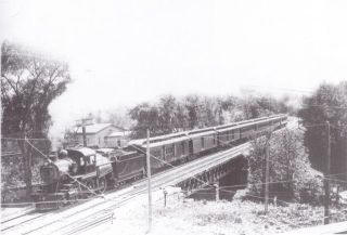
Delaware & Hudson passing over the Kayaderosseras Creek Source: http://ballstonhistory.angelfire.com/images/pic03.jpg
Delaware & Hudson through Ballston Spa
Note Turntable -- This was the approach to the Galway Street Rail Yard
Source: http://ballstonhistory.angelfire.com/images/pic10.jpg
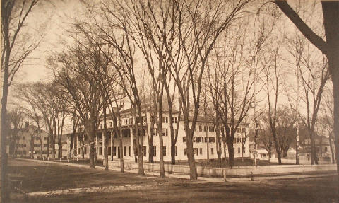
Sans Souci Hotel, built in 1803 and torn down in 1887
Source: http://ballstonhistory.angelfire.com/images/souci.jpg