Biking

"In the field" railroad history adventures...

Sunday, January 3, 2016

Ridgefield Rail Trail

After my earlier event-filled ride at Norwalk River Valley trail,  I was up for something a little calmer. Unfortunately this hike was a little too calm! - BORING? yep but still interesting being a former rail line….

The weather turned cold and gray and certainly didn’t help my perception of the trail at all. The best thing going for it is there are a lot of locals who use the trail to jog so it’s put to good use.
At the start in Ridgefield
This is it!
(about 85% of the trail is like this)
There are a few road crossings to liven things  up a bit :-)
A rock cut
The highlight of the hike was when I pulled out my camera to record how boring it was and as I turned around to film - a bunch of deer scampered across the trail further uphill - that was kinda cool!

End of the Line
CloseUp
Finally back up top where I entered
The trail(ROW) just go a bit further up hill but at this trailhead there is no parking

Why didn't I bike it?

Good question! Bikes are not allowed although I did see lots of tire tracks and a teenager riding with her mother. I guess the powers that be thought that being all downhill,  bikers might get careless with their speed and clip a few joggers.

Here a bit about the railroad history:

In the 1860s, the Ridgefield and New York Railroad (R&N) was proposed to offer a more direct connection to NY. The Danbury and Norwalk did not connect to Ridgefield but came close at a lower elevation further east. The Ridgefield and New York Railroad company purchased and graded many miles of its route to East Port Chester (in Greenwich), but none of the R&N line ever opened.

The Danbury and Norwalk hurriedly constructed a branch to Ridgefield in 1870, in a bid to stop the town from offering financial assistance to the R&N. The branch began down the hill at the former Ridgefield Station, known ever since by the obvious name Branchville. Passenger service ran only until 1925 and the whole branch was abandoned in 1964.

Links

Friday, January 1, 2016

Trolley History Tour - Ballston Spa


Ballston Spa has an interesting history of trains and street cars. At one time, it was serviced by three trolley lines and the railroad. Now of course the large curved embankment long since abandoned by the Delaware & Hudson (D&H) dominates the landscape but there are vestiges of the trolley lines around town as well if you know where to look.

On Dev 26th, before we ventured up the Kaydeross Valley in search of the old mills, Gino DiCarlo took me on a quick loop thru town. Knowing my interest in the trolley era, he wanted to point out a few “not so obvious landmarks” of once omnipresent street car lines.


Map Overview

The map below illustrates the various railroad and trolley lines including the now filled in river and "the island."
Base Map from http://www.openrailwaymap.org

Walking Tour

A walk up the short hill on Prospect Street gave us a glance at how the Kaydeross Railroad (KVRR) came in thru the town. Bath Street was the old electric railroad’s right of way. 
At the old Union Mill - looking south
This is Bath Street - built on the ROW of the Kaydeross Trolley 

We strolled on by the old Tannery...
This was once a thriving industry
...and Gino pointed out where the Schenectady Railway (SRW) snuck across what is now just an insignificant driveway to descend onto Washington Street.
Note ascending pavement - this was the route of the SRW
The old Hudson Valley Railway (HVRW) offices still stand proudly on Front Street but apparently the SRW wan’t allowed to connect with its competitor at this location. 

The two lines came close at the corner of Milton and Washington but never connected! Only when the D&H bought and merged them was a direct connection finally made!
Today
Yesteryear (from the Gino DiCarlo Collection)

Curious cement abutments right over Gordon Creek by the old hot dog place indicates where the SRW crossed and the abutments parallel to the Mechanic Street Bridge over the Kaydeross Creek are remnants of it’s continued route northward.
Looking east from Milton Avenue over the Gordon Creek crossing
Why is this strange short cement wall here? It was where the SRW crossed!
Mechanic Street Bridge
The abutment was where the SRW crossed
A dam and cement remnants at the Mechanic Street bridge are vague reminders of the early mills here

The Now Missing Island

What’s equally fascinating is that a sizable chunk of this area was actually an island replete with a foundry and a mill - appropriately named “Island Mill.” 
This view is looking east from the Rt 50 bridge over the Kaydeross -
 the area to the right was once an island!
Mills highlighted in green

What Happened to Galway Street?

Galway Street was once a rail yard.
Note Rail Yard and Turntable
See the view now -  Google Street View > 
(Galway Street at Science St intersection - looking east)

Take a Google Street View Tour

Bath Street 
At the Mills - North
https://www.google.com/maps/@43.008087,-73.8510289,3a,75y,23.9h,89.07t/data=!3m7!1e1!3m5!1sD_TIOw2XcJ9YQgexs5o_Aw!2e0!6s%2F%2Fgeo2.ggpht.com%2Fcbk%3Fpanoid%3DD_TIOw2XcJ9YQgexs5o_Aw%26output%3Dthumbnail%26cb_client%3Dmaps_sv.tactile.gps%26thumb%3D2%26w%3D203%26h%3D100%26yaw%3D95.748642%26pitch%3D0!7i13312!8i6656

At the Mills - South
https://www.google.com/maps/@43.008087,-73.8510289,3a,75y,207.23h,82.17t/data=!3m7!1e1!3m5!1sD_TIOw2XcJ9YQgexs5o_Aw!2e0!6s%2F%2Fgeo2.ggpht.com%2Fcbk%3Fpanoid%3DD_TIOw2XcJ9YQgexs5o_Aw%26output%3Dthumbnail%26cb_client%3Dmaps_sv.tactile.gps%26thumb%3D2%26w%3D203%26h%3D100%26yaw%3D95.748642%26pitch%3D0!7i13312!8i6656

The Tannery Alleyway
https://www.google.com/maps/@43.00397,-73.851308,3a,75y,218.26h,88.77t/data=!3m6!1e1!3m4!1sRo17tcW3Ai7yuZZrsB3jag!2e0!7i13312!8i6656

The Driveway Descent
https://www.google.com/maps/@43.0029997,-73.8512712,3a,75y,253.83h,71.54t/data=!3m6!1e1!3m4!1shJDD4-_oX-WMQjO5IvgoaA!2e0!7i13312!8i6656

Main Street - The Two shall Not Meet!
https://www.google.com/maps/@43.0033843,-73.8489061,3a,37.5y,12.28h,86.08t/data=!3m6!1e1!3m4!1s2P15OcFTPP6raQWkCZiTbA!2e0!7i13312!8i6656

HVRW Stop on Front Street
https://www.google.com/maps/@43.0024133,-73.85098,3a,90y,326.25h,90.29t/data=!3m6!1e1!3m4!1szYdvyHRZjjGYZtzk5N__ew!2e0!7i13312!8i6656

Milton Ave crossing Gordon Creek (SRW abutment remnants are here)
https://www.google.com/maps/@43.0048692,-73.8490806,3a,75y,123.46h,75.45t/data=!3m6!1e1!3m4!1s40WIuXqOMuH5cAMXhosy_Q!2e0!7i13312!8i6656

Mechanic Street Bridge Abutment


Saratoga County Picture Gallery

Direct Links to Timothy Starr's Historical Photos
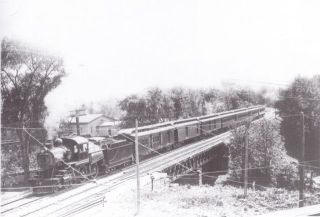
Delaware & Hudson passing over the Kayaderosseras Creek
Source: http://ballstonhistory.angelfire.com/images/pic03.jpg
Delaware & Hudson through Ballston Spa
Note Turntable -- This was the approach to the Galway Street Rail Yard
Source: http://ballstonhistory.angelfire.com/images/pic10.jpg
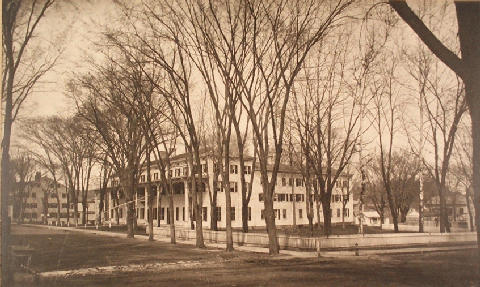
Sans Souci Hotel, built in 1803 and torn down in 1887
Source: http://ballstonhistory.angelfire.com/images/souci.jpg

Further Recommended Reading


The Paper Bag King - A Biography of George West
http://ballstonhistory.angelfire.com/west.htm

Lost Industries of Saratoga County
http://ballstonhistory.angelfire.com/industrial.htm

Ballston Spa, New York (Wikipedia)
https://en.wikipedia.org/wiki/Ballston_Spa,_New_York)

Saturday, December 26, 2015

Retracing the Kaydeross Railroad (Part Three)


Part Three - 

A Few More Mills, the Powerhouse, Boice Park Trails and the Bridge

After leaving the Axe Mill site we continued northward.

County Farm Crossing

Our first stop was the County Farm Crossing. There used to be a road bridge here but it has been removed for quite a while. A short jaunt down the hill took us to the ROW.

ROW looking south
ROW looking north

National Mill

The National Mill remnants were located on private property so a thorough hiking exploration wasn't "in the cards". But there were a few mill remnants easily visible--even using Bing aerials.


Sadly, we didn't get a chance to sniff out what appears to be the former dam across the creek.
Bing Aerial

The Powerhouse

Next was a visit to what was once the Trolley's system's powerhouse, now restored as a lovely apartment building. Gino pointed out the bracket that held the trolley wires (it's a nice touch even tho' the tracks actually ran on the other side of the building...)


Historical Photo: Powerhouse (on the left) and Car barn (on right)
From the Gino DiCarlo Collection

Eagle Mill

At the intersection of Rock City Falls Road and Sherman Road--at a designated Angler's spot--you can see the Eagle Mill remnants.

What's perplexing about this spot is that it appears the creek has been rerouted to the east side of the mill subsequent to the mill's abandonment. The Valuation Map showed the main flow of the creek on the west side of the mill!


Valuation Map courtesy of Gino DiCarlo
and the Saratoga Springs Public Library History Room.
Eagle Mill - Craneville, NY
Remnants of the dam are visible a little further downstream
Panorama shows where the old path of the creek probably went
There was a mysterious ruin lurking in the woods across the creek as well.

Driveway

Following the Trolley ROW on old maps or Bing or Google aerials indicates the ROW veered from the road at this driveway.

Pioneer Mill

The Pioneer Mill in West Milton was a spooky spot for me. The weather was darkening with a sky full of nasty gray clouds and it appeared (although we weren't sure) that someone lived on the grounds. I hastily took a few shots as Gino scoffed at my paranoia.

Valuation Map courtesy of Gino DiCarlo
and the Saratoga Springs Public Library History Room.

Railroad spurs
Looking south from the road  - this was spur #1
Spur #2
This is a Google Street View of the Spillway

Boice Park

Right up the road about 50 ft or so from the Pioneer Mill remnants was the mainline ROW. This has been designated as the Blue Trail (Trail Map >).  I plan on returning in the summer months to mountain bike it.

A bit further up the road, a housing development has been started and the trail (ROW) runs through it.


Looking south
From the development, we hiked in going northward as far as we could...

But eventually the overgrowth was too much to navigate through...
Looking back at the ROW
It would be nice (depending on property ownership of course) if the trail could be developed and continue on to the bridge...
Enhanced aerial showing the ROW

The Bridge

It was getting late in the day and increasingly darker so the last spot we explored was the trolley bridge on Heisler Road.

The ROW going northeasterly from Heisler Road

Trolley Stop

The Rock City Falls mills and whatever can found up at Middlegrove will have to wait for another trek but Gino directed me briefly to the trolley stop.

Other Photos:

It was a great trek and whetted our appetite for future explorations...