On Monday July 11th, 2016, I visited the High Line in Manhattan. This trek was truly an amazing experience and is recommended to anyone who lives and/or visits the Big Apple. The revitalization of this old railroad line into an "aerial garden" is breathtaking.
At the 30th Street Entrance
Skyscraper Construction permeated the surroundings
A perfect day for enjoying the High Line: sunny with a breeze - it was beautiful!
The High Line itself is stunning
...it's like walking in one long garden
In many spots the rails were left intact
One long section is actually raised above the original rail bed and there is a closed off walkway below - this is for the gardeners who maintain the plants.
The gardener's path is visible below
For parts of the Line you are right next to the buildings
Some industry still exists
All along the Line there are shady, secluded spots to sit and relax
A glance back
There are artwork displays scattered along the way
(this is made from discarded tires!)
The immense amount of new skyscrapers going up all around the High Line necessitates frequent scaffolding under the construction areas. A "falling object" safety precaution.
It was cool in the shade under these "tunnels"
In the heart of an urban environment yet refreshingly different! :-)
Looking back
A NYC "parking solution" off to the side
At the turn the High Line, it is nice and wide
Wishful thinking? I kept my eyes peeled but none were out today :-)
Kinda hard to tell from the photo but up ahead is a glass window and an "amphitheater" for people watching...
At the amphitheater. It faces north
I took a selfie - someone nearby made me laugh
(or was I just ecstatic being in such an amazing spot?)
In this building walk through are souvenir booths and a cafe.
All very tastefully "zoned"
The "old" NYC is still present
The "nude sunbather"
A realistic statue that had everybody gawking and smiling!
The "new" NYC loomed high all around
Oo yeah - more rails!
Remnants of the "old "NYC
This was the front edifice of a pier building no longer in existence
The Whitney Museum is at the end of the High Line. It has a skyview option but I didn't check it out this trip....
Close Up of the rails
The Way Back
On the way back, I took a few more photos...
This was a spur that went right into the building - kinda cool!
Looking north - the lawn and mini amphitheater
(benches on left)
Mini Video of the spot below...
From 30th to 34th Street
Once past where I first entered, the High Line continues on a long sweeping curve to 34th Street. Much of this stretch is still being "developed"...
How cool is this? The walkway is between the rails....
Its a long sweeping curve out towards the river. The original "look and feel" of the High Line plant growth is visible on the side...
Looking west out toward the Hudson.
Penn Station rail yard
Looking north
The end of the line on 34th street
About the High Line
The High Line is a public park built on a historic freight rail line elevated above the streets on Manhattan’s West Side. It runs from Gansevoort Street in the Meatpacking District to West 34th Street, between 10th and 12th Avenue.
“A city that had once pioneered so many technological and urban planning solutions, that had dazzled the world with its public works, its skyscrapers, bridges, subways, water-delivery system, its Central Park, palatial train stations, libraries and museums, [currently] appears unable to undertake any innovative construction on a grand scale, and is now consigned to cannibalizing its past and retrofitting it to function as an image, a consumable spectacle.”- Phillip Lopate, director of the MFA nonfiction program at Columbia University.
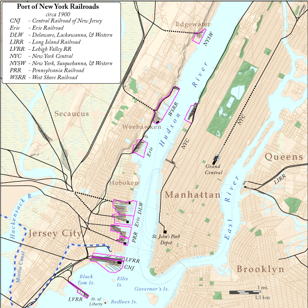
New York City Railroads c. 1900
(By James R. Irwin - Own work)
Before the High Line was constructed, the New York Central Railroad had operated a rail freight line along Tenth Avenue at street level. Men on horseback (known as the “West Side cowboys”) had ridden ahead of the train with red flags or lanterns to warn pedestrians. Despite this precaution, so many citizens had gotten run over that the street acquired the notorious name “Death Avenue.” For over 70 years, since the mid-19th century, public outcry had demanded a safer solution: thus, the High Line was built.
“West Side Cowboy”, 1934. [Photographer unknown]
At the time the High Line went up, the public was turning against elevated structures, such as the “El” subway trains, because their huge looming presence created shadows that darkened the adjoining streets.
On June 28, 1934, the city and railroad held a special dedication ceremony for the new elevated route and the huge new freight station: St. John’s Park Freight Terminal. The terminal covered three city blocks, could handle 14 freight elevators, and serviced 150 trucks. The entire route, all double-tracked from 30th Street to St. John’s Park, was 13 miles long and cost more than $150 million. The New York Central also electrified the corridor but the electric was later abandoned in favor of diesel-electric locomotives.
One unique aspect of the High Line is that it was built in the middle of the block: “in between the buildings” so to speak. Massive industrial-sized buildings could absorb a rail line running right through them and could profit from proximity for quick and easy freight deliveries.
View north from West 17th Street, 1934. [Photographer unknown]
“With the completion of the West Side Improvement, of which this viaduct is one of the more important features, West Side manufacturers, distributors and merchants in general will have transportation facilities unsurpassed anywhere. …Tenants can bring in their raw materials and ship out their finished products swiftly, safely and efficiently over rails at their very doors.” - F.E. Williamson,president of New York Central, at a dedication ceremony for the West Side Viaduct
Although factories and packing houses did indeed congregate around and benefit from the line, by the 1960s, trucks and airplanes had cut significantly into the rail freight business and the rail line was operating deeply in the red. The southern part of the structure was soon dismantled and sadly the last freight delivery on the remaining northern part of the line took place in 1980.
“Much of the High Line’s present magic stems from its passing though an historic industrial cityscape roughly the same age as the viaduct, supplemented by private tenement backyards and the poetic grunge of taxi garages. It would make a huge difference if High Line walkers were to feel trapped in a canyon of spanking new high-rise condos, providing antlike visual entertainment for one’s financial betters lolling on balconies…”- Phillip Lopate, director of the MFA nonfiction program at Columbia University.
Above Grade: On the High Line (Essay) This is a great article!
A native New Yorker traces the pre-history of the High Line, and ponders whether the celebrated park will be a victim of its success.
The former New York & New England Railroad ROW through Southbury, CT is now the Larkin Bridal Trail. This is a great trail!
The Ride
After a railroad-history-filled morning riding the trolleys trails of Woodbury and Middlebury, topped off with a delicious lunch washed down with a double IPA - I was still aching to do more railroad-history-related bike riding.
Next stop was the Larkin Trail. I took a look at the entrance on Rt 63 across from the Hop Brook Park and didn't see the ROW so I went to the Allerton Farms entrance instead. In order to satisfy my curiosity, I biked back to Rt 63 and saw that the ROW did end there - but it was cut off up high. Apparently as Rt 63 was modernized, it removed a lot of the embankment.
Well the ride was a blast - the Trail is very scenic and you ride thru quite a few rock cuts. The eastern section is nicer to ride because it is now mostly single track. The far western end of the trail feels like basically just a wide dirt road.
Allerton Farms entrance looking west
The other way takes you back to Rt 63
Beautiful tree canopy and super picturesque ROW
Man - I love riding thru rock cuts
Abutment - Remnants of the RR Bridge here
(South Street)
Ah - rock cut...
Ooo yeah... another rock cut
Thru marshland near the airport
A picturesque spot - note collapsed structure on right
Power Lines crossing
End of the (official) trail
Yep I t looks like it keeps gong
Parking at the end of the (official) trail
I headed from back here...
There is even a roller for mountain bikers
Of course I had to do it!
Highlights of the Trail
Two Minute Riding Video
History
This trail’s railroad history began in 1881 with completion of the New York & New England Railroad (NY&NE) between western Connecticut and New York. Following NY&NE bankruptcy in 1894, the New York, New Haven & Hartford Railroad (NYNH&H) took over the line until 1939.
Southbury, CT- 1892
New York & New England Railroad
The line was abandoned between Waterbury and Southbury in 1939 and from Hawleyville Junction to Southbury in 1948. The line between Hawleyville and Waterbury had one the region’s steepest grades up to Towantic summit. The severity of that grade is the key reason why the NYNH&H decided to upgrade and double track the alternative longer route from Danbury to Hartford via Derby Jct. in 1908-1911 and allowed this shorter route via Towantic to fade into insignificance.
The Southbury Station was up on the top of Depot Hill. It was razed during the construction of Interstate 84.
The final regular passenger service disappeared in 1932, and by 1937 most of the line east of Southbury was abandoned. The Hawleyville-Southbury portion existed a bit longer but was abandoned in 1948.
The Bridle Trail
The ROW was purchased by a Dr. Charles L. Larkin when the NYNH&H pulled out in 1939, and converted to a bridle path. Larkin was a wealthy Middlebury resident and horse lover and had land abutting the NY&NE ROW near South St. in Middlebury. He gifted it to the state in 1943 for a bridle trail.
A trolley line from Waterbury to Woodbury was completed in 1908 and an amusement park was built on the Lake Quassapaug (formerly known as Quassapaug Pond) as a way to get workers and their families to ride streetcars and railways on weekends. Steady patronage due to the trolley connection helped transform the Quassy Amusement Park into a full-fledged summer resort.
Initially known as the Woodbury and Waterbury Street Railway it soon became part of the Waterbury and Pomperaug Valley Street Railway and was subsequently absorbed by the massive Connecticut Company - the primary electric street railway company in Connecticut. The line was abandoned in the 1930s when visitors began driving their cars to the resort.
A couple of sections of the trolley right of way (ROW) still remain and are "bike friendly." The Middlebury Greenway is a developed "official trail" but the section passing by the Woodbury Reservoir and following the South Brook is undeveloped.
Woodbury Trolley (Backwoods by the Reservoir)
I started at Old Sherman Hill Road and road south towards the Reservoir. It was all downhill and strangely much steeper on the section going north into Woodbury.
It's all downhill going west...
There's a small spot to park on Old Sherman Hill Road
-The Ride-
Old Sherman Hill Road
(pay no attention to the orange signs :-) )
The view up Trolley Bed Road at the start
I rode up to Route 64 first before I hit the woods...
It's a picturesque ride
Definitely glad I was on the mountain bike and not the road bike!
The classic embankment shot
At the end
Some spots were pretty overgrown!
I am found of embankment photos :-)
A bridge
All uphill going back but doable!
Panorama of the Woodbury Reservoir
Another Bridge
It took 20 minutes one way (going down) - probably 12-15 minutes if you wanted to bomb it. Going back - add at least another 5 minutes because its all uphill.
Middlebury Greenway
I next drove over the Middlebury to ride the Greenway. This follows the path of the old trolley ROW and has been fully paved, etc. It would have been better obviously on the road bike but the heavier bike and lots of hills made it more interesting for me.
-The Ride-
I started out from the FireHouse
There are a few historical signs along the way
The first climb goes through a beautiful rock cut
Oops - The official place to start!
This place is now a pizza joint!
Great info!
End of the line
(Mighty boring!)
Short One-Handed Video of the Trail
Sure it was somewhat boring compared to riding single track or a rutted abandoned ROWs in the woods but it was nice to see the Town feature the trolley line and the hilly up and downs made it fun.
Lunch
I grabbed lunch--which included a double IPA!--at this spot: Maggie Mcfly’s. It was wonderful and headed a bit south to Ride the Larking Bridle Trail.